The Ha Giang Loop is one of the most breathtaking routes in Southeast Asia, attracting adventurous travelers who love off-the-beaten-path journeys. To ensure a smooth trip, the Ha Giang Loop map is an essential companion, helping you navigate and discover the most stunning destinations along the way. Get ready for this incredible adventure with Ha Giang City Hostel today!
Guide to the Ha Giang loop map
Where is Ha Giang loop?
Located in and around Ha Giang province, the Ha Giang Loop is a famous motorbike road trip route that attracts travelers with its breathtaking landscapes of limestone mountains, terraced rice fields, and culturally rich ethnic villages. The main journey of this route spans approximately 350 km and is typically completed in 3 to 4 days. However, those who wish to explore more remote areas can extend their trip for a deeper experience.
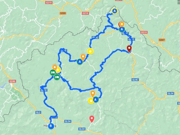
Ha Giang Loop is in and around Ha Giang province
Highlight some of the main stops on a map
Here are some highlights of the Ha Giang Loop map that travelers should not miss:
Ha Giang City – where your tour starts & ends
The Ha Giang Loop map starts from Ha Giang City, located over 300 km from Hanoi. This serves as both the starting and ending point of the journey to explore the northern mountains. Travelers can expect a journey of approximately 6 to 7 hours from Hanoi to Ha Giang.
Du Gia – first night accommodation and waterfall
Du Gia, a commune in Yen Minh District, is about 70km from Ha Giang City and serves as the first stop on the adventure. Known for its pristine landscapes and stunning waterfalls, Du Gia is also an ideal overnight destination. However, the route to this location is filled with winding and challenging mountain roads, requiring skilled driving.
Ma Pi Leng Pass – the famous Ha Giang Loop road
Ma Pi Leng Pass located along National Highway 4C in Meo Vac District, Ha Giang, is one of the most famous and treacherous roads on the Ha Giang Loop. At an altitude of 1,200m above sea level and stretching approximately 20km, this pass not only challenges drivers but also offers breathtaking views, making it an unmissable attraction for any visitor.
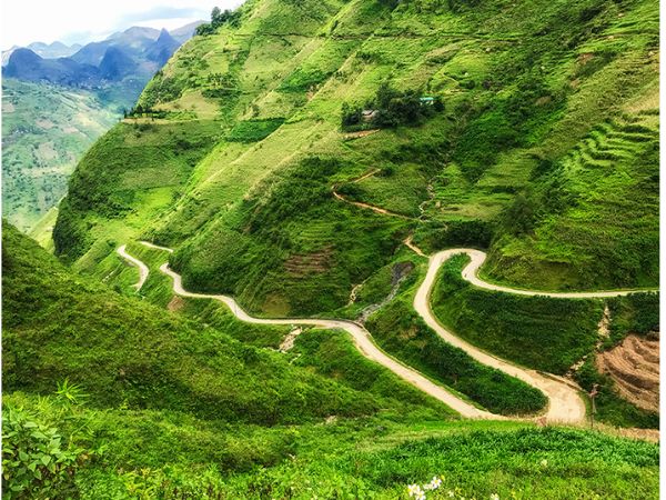
Ma Pi Leng Pass located along National Highway 4C
Northern most point – here you will see the Chinese border
Vietnam’s northernmost point situated about 3.3km from the Lung Cu Flag Tower, provides a unique view of the China-Vietnam border. At an altitude of over 1,600m above sea level, this area is surrounded by primeval forests and secluded valleys. Notably, the Then Van Valley and Dong Van Valley are remarkable sights to explore on this journey.
Lo Lo Village – one of the most remote villages
One must-visit destination on the Ha Giang Loop map is Lo Lo Chai Village. Located about 1 km from the Lung Cu Flag Tower, this tranquil village remains untouched by modern developments, preserving its pristine beauty. Home to ethnic minority communities, Lo Lo Chai captivates visitors with its rustic charm and rich cultural heritage, making it a truly fascinating stop on your journey.
Nam Dam Village – small village of 51 Red Dao households
Nam Dam Village, about 6km from the center of Quan Ba District, is a small village inhabited by the Red Dao ethnic group. With 51 households covering an area of 458 hectares, Nam Dam remains an unspoiled mountain village. Visitors will be captivated by the fresh air and stunning natural scenery here.
Lung Khuy Cave – arguably the most beautiful cave in Ha Giang
Lung Khuy Cave, more than 10km from Quan Ba District center, is one of Ha Giang’s most spectacular caves. Nestled in the mountains, the cave offers a breathtaking panoramic view of Can Ty Commune. On clear days, visitors can admire the beauty of the area right from the cave’s entrance, creating an unforgettable experience.

Lung Khuy Cave is one of Ha Giang’s most spectacular caves
Hang Tham Lin – we’ll take a bamboo raft down the river and into the cave
Tham Linh Cave located in Ngoc Long Commune, Yen Minh District, about 40km from Du Gia, is a newly discovered destination in Ha Giang. Visitors can enjoy a unique experience by taking a bamboo raft along the river into the cave, exploring the mesmerizing stalactites and cave formations. Although still relatively unknown, this location promises to delight adventure seekers.
Khau Lan Waterfall – a hidden spot where you have to hike 15 mins into the woods
Khau Lan Waterfall, situated in Quyet Tien Commune, Quan Ba District, over 40km from Ha Giang City, is a secluded waterfall nestled in a tropical forest. To reach the falls, visitors must trek approximately 10km from Quyet Tien’s center. As an off-the-beaten-path destination, it retains its untouched beauty, appealing to those who appreciate tranquility and nature exploration.
Ha Giang Loop checklist
The following list will take you through the most remarkable destinations on the Ha Giang Loop map, from the central city to hidden villages nestled in the mountains, pristine blue rivers, magnificent terraced fields, and historical landmarks.
Ha Giang city
One of the iconic check-in spots here is Kilometer Zero Milestone, marking the starting point of National Highway 2, a key road connecting Ha Giang with Hanoi and other provinces. For many travelers, especially young adventurers, taking a photo at this milestone symbolizes the beginning of an exciting journey to explore the majestic landscapes of Ha Giang.
Quan Ba Heaven Gate
If you want a panoramic view of Ha Giang, Quan Ba Heaven Gate is a must-visit destination. From Ha Giang City, visitors must travel 46 km to reach this scenic spot. Situated between the peaks of the Twin Mountains, this location stands at an altitude of about 1,500 meters above sea level, rising above the clouds and offering a breathtaking view of the stunning Northeast region.
Quan Ba Heaven Gate is a must-visit destination
Yen Minh town
To reach Yen Minh Town, travelers follow Nguyen Trai – Nguyen Van Linh Street, then continue on National Highway 4C. Along the way, you will pass Quan Ba Heaven Gate and Co Tien Mountain, covering about 30 km before arriving in Yen Minh District. This area boasts a cool climate year-round, fresh air, and a peaceful atmosphere – ideal for those seeking relaxation amid nature.
Dong Van ancient town
Located at an altitude of 1,000 – 1,600 meters above sea level, Dong Van Ancient Town in Dong Van District, Ha Giang, is a place rich in historical and cultural heritage. In the early 20th century, it was home to a few families of the Tay, H’Mong, and Hoa ethnic groups. Later, the Nung and Dao communities settled here, contributing to the town’s vibrancy and liveliness. Despite Ha Giang’s increasing tourism development, Dong Van Ancient Town has retained its ancient, rustic charm, attracting numerous visitors.
Lung Cu Flag Tower
Lung Cu Flag Tower is an octagonal structure standing 33.15 meters tall. The tower is decorated with eight Dong Son bronze drum patterns, and at its base, eight reliefs depict key historical events of Vietnam. To get here from Ha Giang City, travelers follow National Highway 4C for about 160 km northeast to Dong Van Town. From there, a 40 km paved road connects Lung Cu and Dong Van, leading to the peak of Lung Cu.

Lung Cu Flag Tower is approximately 1,470 meters above sea level
Vuong Family Mansion
The Vuong Family Palace (also known as the H’Mong King’s Palace) is a historical architectural masterpiece and a must-visit site in Ha Giang. Located in Sa Phin Valley, Dong Van, this palace was constructed in 1898 and took nine years to complete. Featuring a blend of Yunnan (China) architecture and traditional H’Mong design, the 1,200m² mansion, built on a 3,000m² estate, holds immense historical and cultural significance.
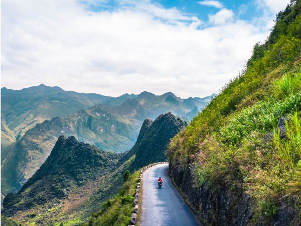
Nho Que River
Originating from Nghiem Son Mountain (Yunnan, China) at 1,800 meters altitude, Nho Que River flows northeast, passing through dense, rugged forests before entering Lung Cu Commune, Dong Van District, and into Vietnam. The river runs beneath the Ma Pi Leng Pass, one of the most breathtaking mountain roads in Ha Giang. For most of the year, the river’s water shines in a vibrant emerald green, standing out against the towering rocky mountains and creating a stunningly poetic yet majestic landscape.
Meo Vac
Located 164 km from Ha Giang City, Meo Vac Town lies within the northern karst plateau and is characterized by limestone mountains. This area remains untouched, featuring cat-ear-shaped rock formations and pristine scenery. Notably, Meo Vac is an ideal stop for travelers looking to conquer the legendary Ma Pi Leng Pass, known for its thrilling U-turns and breathtaking views.
Admire the scenery of Meo Vac
Thon Tha village and waterfall
Tha Village, along with Lup Village, Me Village, and Lung Vai Village, forms a cultural, ecological, and community tourism area near Ha Giang City. Visitors here can immerse themselves in lush green landscapes, admire graceful terraced fields winding through the village, and explore Tien Stream and Ha Thanh Waterfall. In the distance, layers of mountains stretch along the borderline, adding to the mesmerizing beauty of the rocky plateau highlands.
Hoang Su Phi Terraced Rice Fields
The Hoang Su Phi terraced fields, covering 3,000 hectares, extend across six communes, with the most stunning and well-known locations being Nam Ty, Luoc Village, and Phung Village. For centuries, 12 ethnic minority groups have settled here, adapting to the mountainous terrain and integrating lowland farming techniques to cultivate these breathtaking terraces. Over time, these terraced fields have become both an agricultural masterpiece and a cultural heritage site, attracting countless visitors each year.
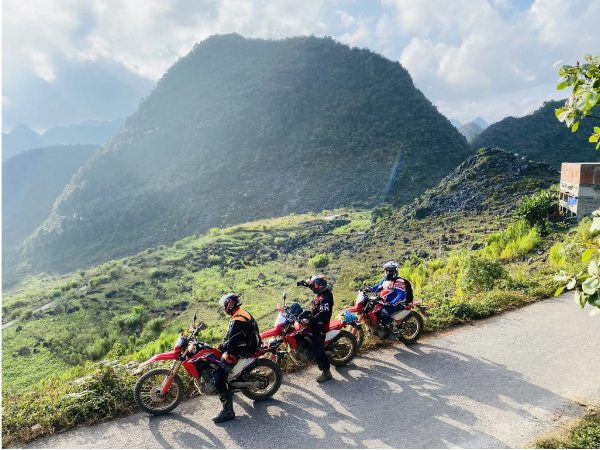
The most popular modes of transportation for the Ha Giang loop
To fully explore the Ha Giang Loop map, you can choose from one of the most popular transportation options for this journey:
Semi-Automatic motorbike
A semi-automatic motorbike is the most popular choice for the Ha Giang Loop due to its flexible handling on mountainous terrain. Unlike manual motorbikes that require clutch control, a semi-automatic allows you to shift gears easily without a clutch lever, making it easier to control speed when climbing steep slopes or descending. If you’re not familiar with riding a semi-automatic, take some time to practice before your trip to ensure a safe journey.
A semi-automatic motorbike is the most popular choice for the Ha Giang Loop
Manual motorbike
A manual motorbike is particularly suitable for rough roads and steep inclines. This type of bike provides greater control over speed, especially when taking sharp turns or navigating long descents. However, manual bikes are best suited for experienced riders. If you’re not comfortable handling a clutch, consider opting for a semi-automatic bike for a safer and smoother ride.

A manual motorbike is particularly suitable for rough roads and steep inclines
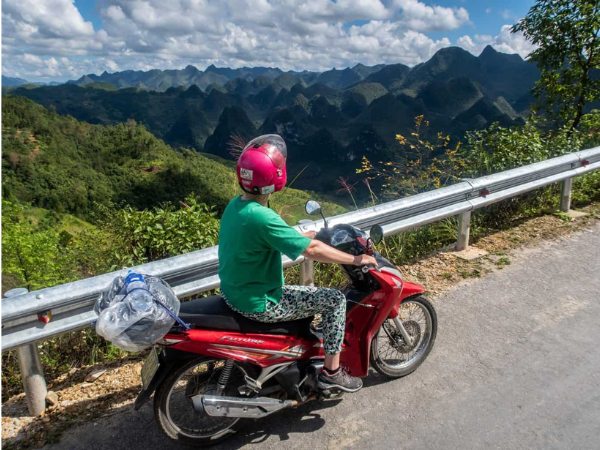
Fully automatic scooter
A fully automatic scooter is the easiest vehicle to operate – just twist the throttle, and you’re on your way. This makes it a comfortable option for flat or gently sloping roads. However, scooters are not ideal for rocky paths, steep mountain passes, or extreme weather conditions. If you choose a scooter, avoid particularly challenging routes to ensure safety throughout your journey.

This type of vehicle is not suitable for steep roads
Ride with a local guide (Pillion)
If you’re not confident in riding on mountain roads or simply want to relax, riding pillion with a local guide is a fantastic way to fully enjoy Ha Giang’s beauty. Experienced local riders will take you through breathtaking routes safely while sharing fascinating stories about the region’s culture and people.
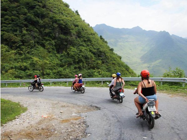
Experienced local riders will safely guide you through narrow roads
Car or jeep
A car or Jeep is a great option for groups, families, or those seeking a more comfortable mode of transportation. However, some narrow and steep roads may be challenging for cars, so it’s essential to research your route carefully before planning your itinerary.

A car or Jeep is a great option for groups or families
Accommodation: From homestays to hotels
Ha Giang offers a wide range of accommodation options to suit every traveler’s needs. Visitors can choose to stay in a homestay for an authentic local experience, relax at a luxury resort, or opt for a hostel for convenience and easy travel. For a stay that is both comfortable and convenient, Ha Giang City Hostel is a great choice.
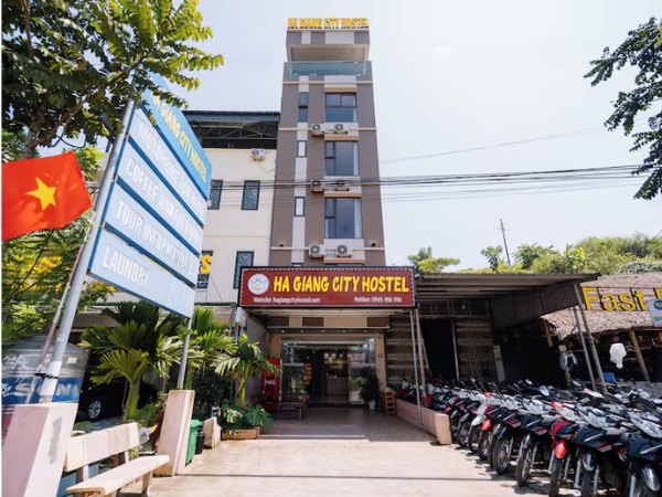
Ha Giang City Hostel is a great choice
Located at 74 Lam Dong, Phuong Thien, Vi Xuyen, Ha Giang, Ha Giang City Hostel offers various room options, including double, twin, triple, and dorm rooms, making it ideal for groups, couples, and solo travelers. With clean and well-equipped facilities, the hostel is in a prime location, allowing guests to explore Ha Giang city effortlessly and prepare for their Ha Giang Loop adventure.
Local tastes to enjoy on the loop include food and drinks
Ha Giang’s culinary scene captivates visitors with its diverse and rich food culture. Here are some must-try delicacies recommended by Ha Giang City Hostel:
Thang Co
Thang Co is a traditional dish of ethnic minorities in the highlands, made from horse, beef, or pork meat and organs, combined with 12 special spices such as cardamom and star anise. The broth, simmered from bones, has a rich and flavorful taste. Initially, the strong smell of offal may be challenging, but the more you eat, the more addictive it becomes due to its unique spicy, aromatic, and fatty flavor.
Sour Pho
Made from fragrant sticky rice noodles, it is served with a sweet and sour sauce, roasted pork, sausage, and stir-fried chili. The sauce is a blend of vinegar, sugar, and tapioca starch, creating a tangy and mildly sweet flavor. It is often topped with fresh herbs, garlic, and shredded green papaya for extra flavor.
Five-Colored Sticky Rice
A traditional dish of the Tay ethnic group, Five-Colored Sticky Rice features five colors: white, purple, green, red, and yellow, symbolizing the five elements. The sticky rice is naturally dyed using plants such as magenta leaves, gac fruit, black rice leaves, and turmeric. Not only visually stunning, but this dish also represents good fortune and is commonly seen during festivals and rituals.
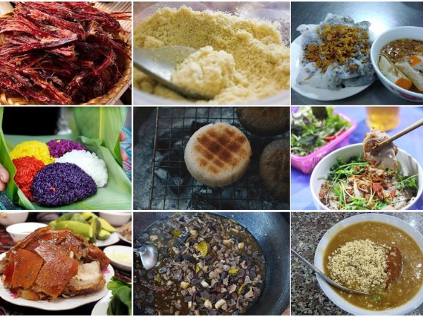
Famous dishes in Ha Giang
Bitter Tuber Porridge
This nutritious porridge is made from ấu tẩu – a poisonous tuber that, when cooked properly, becomes a health-boosting delicacy. The porridge has a light brown color with a slightly nutty and aromatic taste. Locals cook the tuber with glutinous rice and pork trotters to create a rich, creamy texture. A raw egg, black pepper, and chili can be added for extra flavor.
Ancient Shan Tuyet Tea
Shan Tuyet tea is one of Ha Giang’s most famous specialties, often called the “treasure of the highlands.” The tea buds are large, grayish, and covered in fine white hairs like snow. When brewed, the tea has a golden hue, a delicate fragrance, and a slightly bitter taste with a lingering sweet aftertaste. Rich in antioxidants, this tea is not only delicious but also beneficial for health.
Ha Giang Corn Wine
A traditional drink of the H’Mong people, Ha Giang corn wine is made from high-quality corn fermented with wild forest yeast. Brewed using traditional methods, it has a distinctive aroma, smooth sweetness, and does not cause headaches. This warming liquor is perfect for enjoying in the chilly highland weather.
Ha Giang Mint Honey
This rare specialty is harvested only from September to December in the Dong Van Karst Plateau. Made from the nectar of wild mint flowers, Ha Giang mint honey has a light greenish-golden hue, a mild herbal fragrance, and a subtly sweet taste with a slight cooling sensation. Besides its delicious flavor, it is known for its health benefits, including digestive support and throat relief.
Navigating with GPS and Maps
The journey along the Ha Giang Loop can be exciting but also challenging, especially for first-time travelers. You can rely on GPS, maps, and landmarks to navigate your position on the Ha Giang Loop map.
Paper Maps
Mountainous roads often have poor network signals, making offline navigation essential. A detailed paper map displays key landmarks, alternative routes, and scenic spots, helping travelers plan their trip more effectively. Many hostels and travel agencies in Hà Giang also provide free maps with marked stopovers and safety tips for motorbike riders.
Google Maps
Google Maps is an indispensable tool for navigating the Hà Giang Loop, offering real-time directions and estimated travel times. To avoid issues caused by weak signals, it’s recommended to download Hà Giang’s offline map before departure. Combining multiple sources of information will ensure a safe and smooth journey.
Road Milestone
The milestones along the Hà Giang Loop play a crucial role in guiding travelers through winding mountain roads. These stone markers, usually painted red and white, indicate the distance to major towns such as Dong Van, Meo Vac and Yen Minh. They help motorbike riders estimate the remaining distance and travel time. Paying attention to these milestones is particularly useful when phone navigation is unavailable.
Packing list for the Ha Giang loop
If you’re planning a trip around the Ha Giang Loop, check out this essential packing list:
- Warm, waterproof clothing: Ha Giang’s weather can be unpredictable, especially in winter. Layer up with waterproof jackets, along with beanies, gloves, and scarves to stay warm.
- Protective gear (gloves, safety equipment): Wear protective gear to ensure safety while navigating steep mountain roads, preventing scratches and shielding your body from external impacts.
- Hiking and walking shoes: Choose shoes with good grip, slip resistance, and waterproof features for comfort on rugged terrains, especially in rainy conditions.
- Backpack and water bag: Bring a lightweight travel backpack with multiple compartments for easy organization, making it convenient to move between destinations.
- Camera: Capture Ha Giang’s breathtaking landscapes with a professional camera or a smartphone to preserve the most memorable moments of your journey.
- Medicines: Carry pain relievers, anti-inflammatory medicine, stomach medication, and other essential medicines to stay healthy throughout the trip.
- Ha Giang travel map or GPS device: Use a paper map or GPS for navigation, especially in areas with weak network signals.
- Power adapter and backup battery: Bring a power bank for your phone and camera to avoid running out of battery when using GPS, making calls, or taking photos.
- Basic motorbike repair tools: Pack a repair kit including screwdrivers, a tire pump, and lubricating oil for minor roadside fixes.

Wear protective gear when riding through steep mountain roads
Tips for the Ha Giang loop
The Ha Giang Loop is an ideal route to explore by motorbike, allowing you to fully immerse yourself in breathtaking landscapes and thrilling mountain passes. However, to ensure a smooth and enjoyable trip, keep these important tips in mind:
- Choose the right time to travel: Always start your journey early in the morning to have ample time to stop, take photos, and appreciate the stunning scenery along the way. Avoid riding at night, as the winding mountain roads have limited visibility and can be dangerous.
- Carry cash along with your ATM card: Check ATM locations before starting your trip and always have some extra cash on hand, as many places in Hà Giang do not accept card payments.
- Obtain an International Driving Permit (IDP): If you are a foreign traveler planning to ride a motorbike in Vietnam, ensure you have an International Driving Permit (IDP). It’s a simple and inexpensive process but can help you avoid fines if you are stopped for a traffic check.
- Take photos of your rental bike: If you rent a motorbike, inspect its condition carefully and take photos of any existing scratches or damage. This will help you avoid unnecessary charges when returning the bike, as some rental companies may try to hold you accountable for pre-existing damage.
- Download Vietnamese on Google Translate: English is not widely spoken in Hà Giang compared to other tourist destinations, so download Vietnamese on Google Translate for offline use. Additionally, learning a few basic phrases like “Thank you” (Cảm ơn) or “Hello” (Xin chào) can help you connect with locals and bring smiles to their faces.
With the Ha Giang Loop map we’ve shared, you can confidently conquer this legendary route safely. If you’re planning a trip to Ha Giang and looking for a comfortable place to stay with various traveler-friendly services, Ha Giang City Hostel could be the perfect choice!
>>> Learn more: